Overview
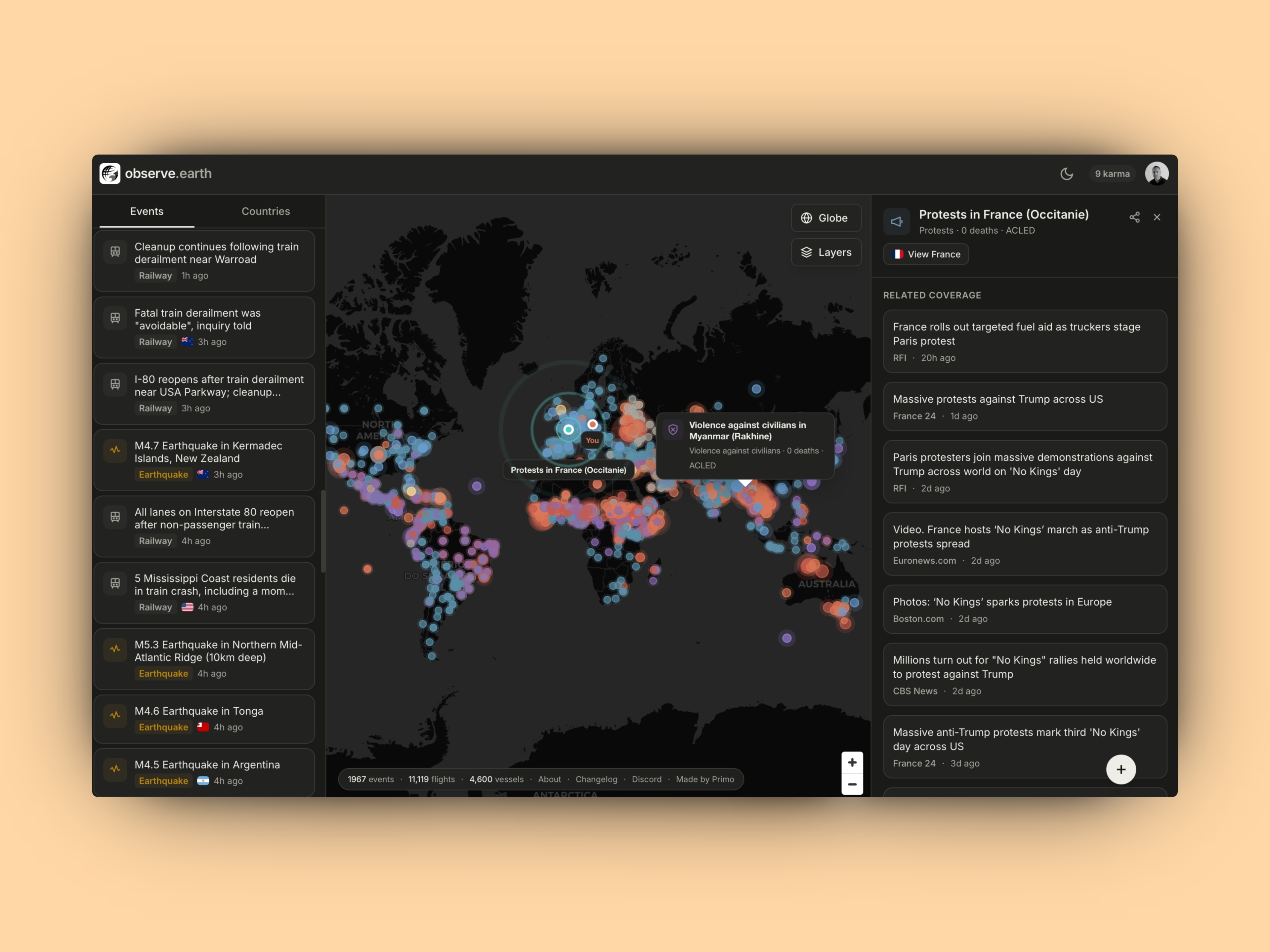
- See global events unfold as they happen with real-time satellite data and AI-powered analysis, enabling immediate awareness of natural disasters, conflicts, and social movements.
- Identify emerging trends and patterns with multi-level insights and daily summaries, supporting data-driven research and strategic forecasting.
- Make informed, unbiased decisions based on fact-based reporting from raw satellite imagery, free from editorial bias or narrative.
- Contribute to a collaborative understanding by sharing your own observations and insights, enriching the platform's interactive event reporting.
- Apply live data to practical outcomes like environmental conservation, urban planning, and resource management through actionable, up-to-date global insights.
Pros & Cons
Pros
- Real-time global platform
- Satellite data processing
- Real-time images
- Enables user data analysis
- Promotes collaborative learning
- Encourages data interpretation
- Broad user base
- Useful for environment conservation
- Facilitates urban planning
- Effective in weather forecasting
- Aids in resource management
- Monitoring environmental changes
- Tracking weather phenomena
- Geographical survey capabilities
- Studies urban development trends
- Wildlife pattern study
- Decisions making support tool
- Facilitates research
- Influences policy making
- Educational applications
- Bias-free presentation
- Interactive event reporting
- User-contribution system
- Up-to-date insights
- Present data in user-friendly way
Cons
- No offline mode
- Depends on satellite availability
- Possible accuracy issues
- No user customizability
- No data export functionality
- No multi-language support
Reviews
Rate this tool
Loading reviews...
❓ Frequently Asked Questions
Observe Earth is a real-time global platform specifically configured for the task of observing and sharing contemporary global events. Its primary utilization is based on advanced technology to provide real-time insights into worldwide happenings.
Observe Earth employs user-friendly interface to present global events, making it easy for users to analyze, understand and contribute to the bigger picture of the global situation.
Yes, Observe Earth not only allows, but encourages its users to share their findings on the platform. This contributes to an interactive event reporting and discussion.
Observe Earth maintains a policy of avoiding bias by focusing purely on data and facts. This emphasis on fact-based information allows users to come to their own conclusions.
Observe Earth provides a profound and an objective understanding of global affairs via up-to-date insights into current events and interactive discussions. Being part of this can certainly enhance your comprehension of world affairs.
'Real-time data', in the context of Observe Earth, refers to the continuous update of information on global events as they occur, providing a live representation of worldwide happenings.
Indeed, as Observe Earth is based on real-time data, it helps its users stay updated with recent developments around the globe as they occur.
Observe Earth proves to be a reliable tool for researching global events, as it provides real-time, unbiased and fact-based insights into the happenings around the world. Users can also contribute to and benefit from the interactive reporting and discussion feature.
Observe Earth is indeed an excellent tool for anyone seeking an unbiased reporting platform. Its commitment to fact-based reporting allows enthusiasts to understand and relate to global events objectively.
Observe Earth, being a real-time global platform, does not focus on specific topics but provides a broad view of global events, covering various domains like Technology, Health, and Finance.
You can contribute to the interactive event reporting on Observe Earth by sharing your findings. This offers an added perspective and promotes inclusive discussion.
You can use Observe Earth for pattern analysis by monitoring the real-time data for global events it offers. It allows analyzing patterns concerning time, place, and nature of the events amongst other things.
Observe Earth utilizes advanced technology to continuously update its data about global events. The specific attributes of this technology are not listed on their website.
Yes, Observe Earth presents straightforward, unbiased, fact-based information, encouraging you to form your own conclusions about global affairs.
Observe Earth provides global insights by offering real-time tracking and reporting of global events, leading to a comprehensive view of worldwide happenings.
When talking about Observe Earth, 'interactive platform' means its ability to allow users to not only observe global events but also to share their findings and participate in discussions, thereby contributing to a more complete picture of global affairs.
The primary objective of Observe Earth is to deliver an in-depth and objective understanding of global affairs by presenting real-time, fact-based information about events happening worldwide.
Observe Earth constantly provides real-time information and analysis of worldwide events and patterns. It provides a platform to observe, understand, and draw conclusions about these patterns, enhancing your comprehension of global events significantly.
Yes, Observe Earth is a resourceful platform for researchers due to its access to real-time data, unbiased reporting, user-friendly interface, and an interactive platform for discussion.
Observe Earth covers multiple dimensions of global affairs, providing up-to-date insights into world events regardless of their respective fields including, but not limited to Technology, Health, and Finance.
Observe Earth uses AI technology to process satellite data effectively, providing real-time images and conducting data analysis. Utilizing AI, it presents a continually updated view of our planet, enabling users to study and understand the world in its current state.
Observe Earth provides a wealth of data derived from satellite imagery, allowing users to analyze global events and patterns. This includes information on environmental changes, weather phenomena, geographical conditions, urban development trends, and wildlife patterns.
Observe Earth uses advanced AI technology to process satellite data. This enables the platform to convert vast quantities of raw satellite data into user-friendly images and pertinent insights that can be used for various purposes, such as research, education, and policymaking.
You can use Observe Earth for a wide array of purposes, ranging from observing environmental changes, tracking weather phenomena, and surveying geographical conditions to understanding urban development trends and studying wildlife patterns. It can also be a valuable tool for decision-making in environment conservation, urban planning, weather forecasting, and resource management.
Given its real-time nature, Observe Earth is continually updated with the latest developments. It strives to deliver the most recent satellite images and insights into what is happening around the world.
Yes, Observe Earth can be extensively used for educational purposes. Its user-friendly data interpretation and rich repository of global patterns provide a hands-on approach for students and educators to understand and analyze current global affairs.
Observe Earth can significantly assist with environmental conservation. By monitoring environmental changes and trends in real-time, it allows researchers, policymakers, and individuals to gain a profound understanding of the planet's state, enabling informed conservation efforts and policies.
Observe Earth offers various benefits for policymakers. The platform provides comprehensive and up-to-date data on environmental changes, urban development, and global trends, which can assist policymakers in making informed decisions that are in line with the current state of affairs.
Yes, Observe Earth can be used to monitor weather phenomena. Its real-time satellite data processing and analysis provide valuable information on ongoing weather patterns and changes, which can aid in weather forecasting and preparedness.
Observe Earth can contribute significantly to urban planning by providing accurate and real-time satellite images and data on urban development trends. Urban planners can use these insights to make informed and strategic decisions regarding infrastructure development, management, and conservation.
Data analysis in Observe Earth is performed using advanced AI technology. This technology converts raw satellite data into usable insights, allowing users to analyze global events and patterns and come to their own conclusions.
Observe Earth can be used by a wide range of users, including enthusiasts, researchers, data scientists, environmentalists, policymakers, educators, and anyone interested in real-time global affairs.
Yes, Observe Earth encourages users to share their observations and insights, promoting interactive event reporting and discussion. This collaborative approach contributes to a broader understanding of the global situation.
Observe Earth can assist with resource management by providing real-time images and data on a wide range of patterns, including environmental changes, urban development, and wildlife patterns. These insights can enable effective allocation and management of resources.
Yes, Observe Earth does track and study wildlife patterns. The real-time satellite data provides valuable insights into wildlife trends and movements, contributing to research efforts and wildlife conservation strategies.
Yes, Observe Earth has been designed to be user-friendly. It presents complex global data in a way that's easily interpretable and encourages users to partake in discussions, sharing their findings and insights.
Yes, Observe Earth offers real-time images. It leverages AI technology to process satellite data, providing up-to-date images that reflect the current state of our planet.
The potential limitations of Observe Earth might be subject to changes over time as the tool's capabilities continue to evolve with advancements in AI technology and more comprehensive satellite data.
Observe Earth ensures objectivity and avoidance of bias by focusing solely on presenting facts derived directly from satellite data. It encourages users to make their own deductions from the data, thereby avoiding any personal or corporate bias.
Pricing
Pricing model
Free
Paid options from
Free