
Overview
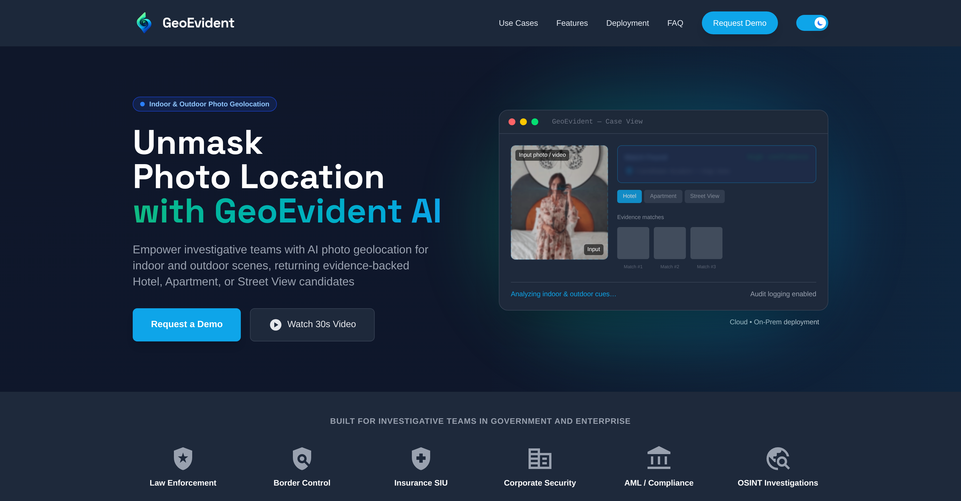
- Verify the exact location of any image or video to validate sources and claims, using AI that analyzes distinctive visual cues like interior layouts and streetscapes.
- Authenticate apartment listings and insurance claims by matching submitted imagery against location-linked visual sources to identify inconsistencies.
- Generate structured, audit-ready case reports with ranked location candidates and visual evidence for internal review and downstream workflows.
- Maintain full data control for sensitive investigations with flexible on-premise or secure cloud deployment options and role-based access.
- Support OSINT, journalism, and compliance due diligence by locating where media was captured for story verification and geospatial fact-checking.
Pros & Cons
Pros
- Designed for investigation teams
- Indoor and outdoor image analysis
- Visual cue-based location matches
- Adaptable to varied applications
- Supports OSINT investigations
- AML and compliance due diligence
- Provides verifiable location matches
- Supports image and video analysis
- Can verify rental listing images
- Secure cloud or on-premise deployments
- RBAC for access control
- Maintains audit logs
- Generates structured case reports
- High confidence matching system
- Analyzes interior layouts, furnishings
- Identifies hotel properties from photos
- Supports story verification and fact-checking
- Ranked candidates of location matches
- Exportable record of results
- Flexible deployment options
- Supports air-gapped deployment
- Containerization delivery support
- Data retention options
- Locates image or video capture locations
- Customizable data residency options
Cons
- Requires distinctive visual cues
- Inconsistent accuracy
- No real-time tracking
- Cloud deployment risks
- Limited indoor geolocation
- Depends on photo quality
- Can't geolocate social media
- Limited to specific sectors
- Possibly slow analysis time
- Requires secure environments
Reviews
Rate this tool
Loading reviews...
❓ Frequently Asked Questions
GeoEvident analyzes photos for geolocation using artificial intelligence. The AI examines both indoor and outdoor photographic material to identify potential location matches based on visual cues present in the images.
GeoEvident supports a wide range of investigations including law enforcement, border control, insurance claim verification, investigative journalism, OSINT (Open-source intelligence) investigations, and AML/compliance due diligence.
Yes, GeoEvident can indeed identify indoor locations from photos. It uses AI technology to analyze images and pinpoint possible matches for interiors like hotels and apartments based on visual similarities.
GeoEvident verifies location candidates by providing matches with evidence-backed similarities. These matches are generated through AI analysis and are verifiable, giving analysts the ability to review, compare, and document them.
Yes, GeoEvident can be used for source validation of images and videos. It's capable of locating the capture locations of videos and images, which can then be used to verify the authenticity of the source.
RBAC in GeoEvident manages access control. It supports compartmentalized work, oversight, and traceability across teams and environments, ensuring secure access to the platform and its functions.
GeoEvident aids in insurance claim verification by analyzing claim imagery against location-linked visual sources. This allows it to identify inconsistencies and reduce the manual verification workload, thereby making the insurance claim verification process more efficient and reliable.
Yes, GeoEvident can be deployed on both cloud and on-premises networks. It's designed to accommodate various types of investigations and can adapt to different security requirements.
GeoEvident handles sensitive investigations by allowing for deployment options that include secure cloud or on-premise networks with role-based access control and audit log maintenance. This ensures maximum data security and oversight.
GeoEvident supports AML compliance and due diligence by verifying location-linked imagery tied to entities, listings, or claims. With its traceable outputs, it can provide valuable data for reviews, contributing to enhanced due diligence.
GeoEvident case reports include key findings, analyst notes and an exportable record of results. These structured reports can be used for internal review and downstream workflows.
Yes, GeoEvident can authenticate apartment or rental listing images. It verifies whether the imagery matches the claimed listing and can surface likely building/location candidates for further verification.
Yes, GeoEvident does support OSINT investigations. Its AI technology is used for open-source intelligence, offering valuable resources for such investigations.
GeoEvident handles audit logs by allowing the recording of actions to support oversight. This feature enhances transparency and contributes to maintaining high security standards.
GeoEvident aids investigative journalism by analyzing and locating where images or videos were captured. This supports story verification, source validation, and geospatial fact-checking.
GeoEvident can support border control investigations by identifying potential location matches based on visual cues present in images. This can be used for various border control activities including identifying undisclosed locations, illegal crossings, and more.
Yes, GeoEvident can identify outdoor locations from photos. It analyzes outdoor scenes and returns evidence-backed location candidates which can be streetscapes or other outdoor locations.
GeoEvident supports law enforcement investigations by leveraging its AI-based image analysis to provide verifiable location matches. This aids law enforcement agencies in evidence gathering, crime scene investigation, and other law enforcement activities
GeoEvident verifies image authenticity by checking against visual sources and assessing similarities. This allows for the confirmation of apartment or rental listing images, and other location-linked imagery.
Key features of GeoEvident aiding in government use include analysis of both indoor and outdoor photographic material to identify location matches, accommodation for sensitive investigations via secure cloud or on-premises networks, management of access controls via RBAC, and structured case report outputs for internal review and downstream workflows.
GeoEvident is an AI-powered Geolocation Intelligence Platform designed for investigation teams. It uses artificial intelligence to analyze both indoor and outdoor images for identifying possible location matches based on visual cues. It's used across a variety of sectors, such as law enforcement and border control, and assists in insurance claim verification, investigative journalism, and OSINT investigations. GeoEvident verifies matches by comparing visual similarities in the images and it can be deployed through secure cloud or on-premise networks. Additionally, it emphasizes fairness and transparency with managed access via RBAC and contributes to oversight with maintainable audit logs. GeoEvident also offers structured case reports with key findings and analyst notes.
GeoEvident can benefit a variety of sectors, primarily those requiring geolocation intelligence for investigative work. These sectors include law enforcement, border control, insurance, corporate security, and compliance. GeoEvident is also beneficial for subjects like investigative journalism, OSINT investigations, and AML/due diligence.
GeoEvident works by using artificial intelligence to analyze images and identify possible location matches based on visual cues present. The platform surfaces likely location matches for varied contexts such as a hotel, apartment, or street view. It's characterized by a high confidence matching system that identifies and verifies locations by analyzing distinguishing elements like interior layouts, furniture arrangements, architectural features, and urban details in images. Users can compare and document the returned matches, which are ranked based on visual similarities.
GeoEvident analyzes both indoor and outdoor photos. It's capable of analyzing images from different contexts, including interiors of hotels and apartments, public venues, and street scenes. GeoEvident can also analyze video files or clips through extracted frames.
In law enforcement and border control, GeoEvident's geolocation intelligence can be used to assist in investigations by locating the capture locations of video and images for source validation. It can also verify location-linked imagery for due diligence reviews. By analyzing visual cues in images or videos, GeoEvident is able to identify possible locations, such as hotels, apartments, or street views, potentially aiding in cases related to illegal activities, human trafficking, or border security misconducts.
GeoEvident verifies insurance claims by cross-checking claim imagery against location-linked visual sources. It assists in identifying inconsistencies and reducing manual verification workload, which is particularly useful in dealing with fraudulent claims. It allows insurance investigators to match the location implied by the damage photos to the insured property location.
In investigative journalism, GeoEvident assists by analyzing images or videos to locate where they were captured, aiding in story verifications and geospatial fact-checking. By verifying the source and location of images, it promotes authenticity and accuracy in journalistic investigation.
In OSINT investigations, GeoEvident provides geolocation intelligence by analyzing images and videos, helping locate their capture locations. This assists in identifying the source and location involved in various types of investigations, aiding in story verification, source validation, and geospatial fact-checking.
Yes, GeoEvident can verify the authenticity of apartment or rental listing images. It does this by analyzing the imagery provided and surfacing likely building/location candidates for follow-up verification. The system identifies specific properties from photos by comparing layouts, furnishings, and distinctive details.
GeoEvident aids in verification of location-linked imagery tied to entities, listings, or claims. It does this by analyzing the imagery for distinctive visual cues and returning ranked candidates with supporting visual similarities. This system helps verify the actual location linked to imagery presented.
Yes, GeoEvident can be deployed on both secure cloud and on-premise networks. It provides flexible and secure deployment options to match an organisation's security and governance requirements. This includes a managed cloud deployment with enterprise access controls and configurable data residency and retention options, or on-premise deployment for full data control that supports air-gapped workflows.
GeoEvident manages access control via RBAC (Role-Based Access Control). This allows for compartmentalized work, oversight, and traceability across different teams and environments, ensuring that sensitive data is accessed only by authorized personnel.
GeoEvident's audit logs provide a record of operations performed on the platform. They can support oversight and maintain traceability across teams and environments, keeping a detailed history of all activities. This can be especially important for maintaining accountability and assisting in investigating irregularities or breaches.
GeoEvident's structured case reports contain key findings, analyst notes and an exportable record of results, which can be used for internal review and downstream workflows. The ranked location candidates are included along with their visual similarities for validation. This format provides a comprehensive and organized outlook of the investigative results, making it easy for review.
GeoEvident can match a variety of locations in images, such as indoor and outdoor scenes, hotels, apartments, and street views. By examining visual cues and distinctive details in these locations, the platform is able to identify potential matches based on the imagery analyzed.
GeoEvident detects and analyzes visual cues in images using artificial intelligence. Its high confidence matching system identifies location by analyzing distinctive details such as interior layouts, furnishings, architectural features, and urban details. These visual cues are then used to determine potential location matches, which are presented as ranked candidates.
Data security in GeoEvident is maintained through a combination of methods. One is through its deployment options, as it can be securely deployed on either cloud-based networks or on-premise networks. Moreover, access control is maintained via Role-Based Access Control (RBAC) and all actions are recorded through audit logs to support oversight. This method ensures that the data is not only guarded from external threats, but also allows for internal accountability and secure data management.
Yes, GeoEvident can be used for both indoor and outdoor photo geolocation. It analyzes photographic materials taken from both settings to identify possible location matches based on the visual cues present. This allows it to unmask photo locations through AI geolocation intelligence.
GeoEvident analyzes a range of distinctive features in images. These include interior details such as layouts and furnishings, as well as architectural features and urban details. By examining these distinguishing elements, GeoEvident is able to compartmentalize images according to their visual cues, making location matches more accurate.
GeoEvident supports video verification by analyzing extracted frames from video files or clips. Like its photo analysis capabilities, it identifies possible location matches in video content based on visual cues present in the extracted frames. This allows GeoEvident to locate the capture locations of video content, supporting its use cases in entity verification and investigative analysis.
Pricing
Pricing model
Paid
Paid options from
N/A